
It’s official: France is launching a national program for digital twins of territories. Named JUNN (National Digital Twin), this initiative brings together public bodies IGN, Cerema and Inria, along with the editor 1Spatial France, around a shared goal: to build an open, sovereign technological base that can simulate, visualize, and anticipate changes across the French territory in the face of increasingly pressing climate shifts.
What is a digital twin of territories?
A digital twin of territories is a virtual, dynamic replica of a physical space. By stitching together static and dynamic data—from connected sensors, satellite imagery, and LiDAR surveys—and coupling them with simulation tools, it enables visualization, analysis, and forecasting of the impact of events or planning projects.
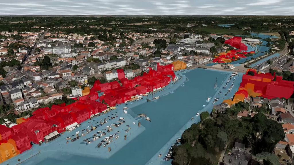
Specifically: simulating the consequences of a hundred-year flood, anticipating urban heat islands, assessing coastline retreat, or modeling the impact of new transport corridors on traffic.
Several French regions already possess such tools: Vendée, the Port of Bordeaux, the Lille metropolitan area, Angers Loire Métropole, and Rennes. JUNN aims to accelerate the deployment of these initiatives and to interconnect them at the national level.
€40 million investment over three years
The overall program budget comes to nearly €40 million over three years (2026-2029), including €25 million funded under the France 2030 plan, administered by the Banque des territoires.
JUNN also aims to structure a French industrial ecosystem dedicated to digital twins, enabling companies in the sector to focus on high value-added services without having to rebuild the technical foundations for each project.
The program’s primary objective is to provide a common, shared, interoperable technological platform. Today, existing digital twins operate in silos: data models are heterogeneous, and simulations performed in one territory cannot be reused elsewhere. JUNN intends to solve this by harmonizing standards, sharing software building blocks, and establishing a national common heritage of geographic data.
Within eighteen months, the platform should host initial 3D data covering several departments, immersive visualization tools, and connections to high-performance simulation environments. The first pilot territories have already been identified: Alpes-Maritimes, Charente-Maritime, Gironde, and Ille-et-Vilaine.
A consortium of 14 partners and more than 200 stakeholders
Technical and operational coordination is provided by 1Spatial France, with Camptocamp supporting the architecture and infrastructure.
The consortium brings together 14 partners with complementary expertise: CNES for space data and high-performance computing, IFPEN for orchestration of complex systems, and BRGM for soil and subsurface resource modeling.
The production of digital mock-ups across experimentation territories is entrusted to Geofit/IGO, Siradel, and LuxCarta. Géodata Paris and GeometryFactory contribute to the 3D models, knowledge graphs, and artificial intelligence. Cap Digital is tasked with preparing the exploitation phase by structuring the business model. Dassault Systèmes will engage upstream on a climate adaptation use case for cities by mobilizing its multiphysics simulation capabilities.
More broadly, JUNN relies on a “Team France of territorial digital twins” gathering more than 200 actors (pioneering local authorities, consultancies, small and medium-sized enterprises, start-ups, and research institutes) that answered a 2024 call for common assets.
Concrete use cases
The priority themes have been identified from needs raised by the territories: prevention of natural hazards (floods, coastal erosion, seismic risks), sustainable urban planning, mobility, forest and water resource management, development of renewable energy, biodiversity assessment, and epidemic control.
On this last point, the Accelerated Renewable Energy Production (APER) law requires local authorities to identify zones suitable for renewable energy development. JUNN will enable cross-referencing within a single environment the solar or wind potential, environmental constraints, urban planning rules, and land availability, where today these tools are often dispersed and difficult to link.
Three research axes
The program centers on three scientific challenges. The first concerns representation: reconstructing faithful, semantically enriched 3D models capable of integrating data from very diverse origins at different scales. The second concerns interoperability: ensuring that existing digital twins can communicate and that simulations can be reused from one territory to another. The third concerns visualization and interaction: making these tools accessible to elected officials, technicians, crisis managers, or citizens, without requiring prior technical expertise.
Roadmap
Development will be incremental. The first year will focus on establishing the basic technical tools and producing the initial sets of 3D data. The second year will see the first connections of applications enriching the use cases. In the third year, the system should be complete, reliable, and scalable for large-scale use. The operational exploitation phase will begin in 2029, on the basis of a sustainable economic model combining public funding, private partnerships, and contributions to service costs.